Open ledger · AOD.UK.TYNEMOUTH.V00 · ORIGINALClose ledger · AOD.UK.TYNEMOUTH.V00
Ledger AOD.UK.TYNEMOUTH.V00
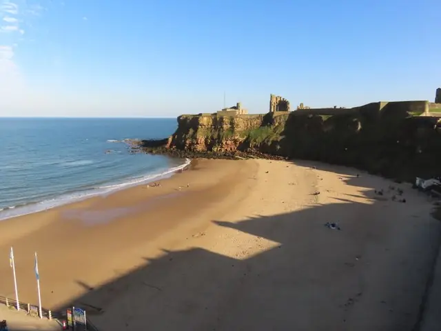
Evening at King Edward's Bay, Tynemouth
Evening at King Edward's Bay, Tynemouth. This photograph is used as a geographic witness to the place, not as evidence of the historical date shown in the chapter.
- Visual description
- Evening at King Edward's Bay, Tynemouth
- Nature
- original
- Medium
- Open-licence photograph
- Source
- Wikimedia Commons / Geograph · CC BY-SA 2.0
- Reviewed
- Josh Wildman
THE RIVER MOUTH
Tynemouth
A historic river mouth whose Longsands became the institutional centre of north-east surfing.
Scroll to follow the shoreline through time
Longsands lies immediately north of the Tyne’s defended entrance.
North Sea swell reaches a broad urban beach within a coast shaped by harbour walls, headlands and the river.
Sources for this chapter
BEFORE SURFING
The headland watches the route
Tynemouth’s priory, castle and later coastguard uses reflect the long strategic importance of the river mouth.
The beach developed beside a route of trade and naval movement.
Sources for this chapter
1995
A surf business makes a permanent base
Tynemouth Surf Co was established in 1995.
Equipment, local advice and lessons gave the growing north-east line-up durable shore infrastructure rather than relying on occasional visiting provision.
Sources for this chapter

Open ledger · AOD.UK.TYNEMOUTH.V01 · ORIGINALClose ledger · AOD.UK.TYNEMOUTH.V01
Ledger AOD.UK.TYNEMOUTH.V01
The Long Sand, Tynemouth
The Long Sand, Tynemouth. This photograph is used as a geographic witness to the place, not as evidence of the historical date shown in the chapter.
- Visual description
- The Long Sand, Tynemouth
- Nature
- original
- Medium
- Open-licence photograph
- Source
- Wikimedia Commons / Geograph · CC BY-SA 2.0
- Reviewed
- Josh Wildman
1998–2015
Lifesaving moves to Longsands
North Sea Volunteer Lifeguards formed in 1998 and moved its beach base to Longsands in 2015.
Training connected surf participation to rescue skills and a formal pathway for young lifeguards.
Sources for this chapter
THE LIVING MAP
The mapped place
Tynemouth is recorded at 55.020° N, 1.423° W. A surf map fixes a name to one stretch of moving water, but the place changes with tide, swell direction, wind and the shape of the seabed.
Sources for this chapter
Open ledger · AOD.UK.TYNEMOUTH.V00 · ORIGINALClose ledger · AOD.UK.TYNEMOUTH.V00
Ledger AOD.UK.TYNEMOUTH.V00
Evening at King Edward's Bay, Tynemouth
Evening at King Edward's Bay, Tynemouth. This photograph is used as a geographic witness to the place, not as evidence of the historical date shown in the chapter.
- Visual description
- Evening at King Edward's Bay, Tynemouth
- Nature
- original
- Medium
- Open-licence photograph
- Source
- Wikimedia Commons / Geograph · CC BY-SA 2.0
- Reviewed
- Josh Wildman
TODAY
The north-east’s everyday surf beach
Longsands now supports schools, clubs, competition, lifesaving and a large local line-up within the daily life of Tynemouth.
Its strength is that surfing has become ordinary civic culture, not a seasonal spectacle.
Sources for this chapter
THE LEDGER
Sources and credits
This exhibition is built from local, institutional and sporting records. The source ledger keeps the claims visible and leaves space for correction as further local evidence emerges.
Sources for this chapter
Artefacts in order of appearance
Evening at King Edward's Bay, Tynemouth
AOD.UK.TYNEMOUTH.V00 · original · Wikimedia Commons / Geograph · CC BY-SA 2.0
The Long Sand, Tynemouth
AOD.UK.TYNEMOUTH.V01 · original · Wikimedia Commons / Geograph · CC BY-SA 2.0
Editorial record
Full UK edition. Historical claims are linked to the local, public and sporting records used to write the exhibition. Cartography is generated from the PeakWave location catalogue.