Open ledger · AOD.UK.SALTBURN.V00 · ORIGINALClose ledger · AOD.UK.SALTBURN.V00
Ledger AOD.UK.SALTBURN.V00
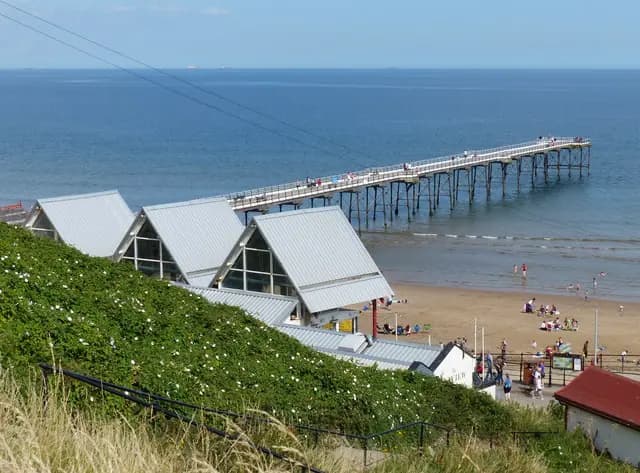
Saltburn-by-the-Sea pier and Saltburn Sands
Saltburn-by-the-Sea pier and Saltburn Sands. This photograph is used as a geographic witness to the place, not as evidence of the historical date shown in the chapter.
- Visual description
- Saltburn-by-the-Sea pier and Saltburn Sands
- Nature
- original
- Medium
- Open-licence photograph
- Source
- Wikimedia Commons / Geograph · CC BY-SA 2.0
- Reviewed
- Josh Wildman
BEFORE THE TOWN
Saltburn-by-the-Sea
A railway-built Victorian resort whose pier now overlooks a major north-east surf community.
Scroll to follow the shoreline through time
Saltburn’s sand lies where Skelton Beck reaches the North Sea beneath high ground.
Before the resort, the shore was associated with a small hamlet, fishing and smuggling stories.
Sources for this chapter
1861
A town is founded with the railway
Henry Pease founded the planned town in 1861 as the railway arrived from Middlesbrough.
Saltburn was built around access to the sea rather than slowly adapting an old town to tourism.
Sources for this chapter
1869–1884
Pier and cliff railway connect the levels
The pier opened in 1869 and the water-balanced cliff railway in 1884.
Together they joined rail town, cliff top and beach in a single visitor journey.
Sources for this chapter
Open ledger · AOD.UK.SALTBURN.V01 · ORIGINALClose ledger · AOD.UK.SALTBURN.V01
Ledger AOD.UK.SALTBURN.V01
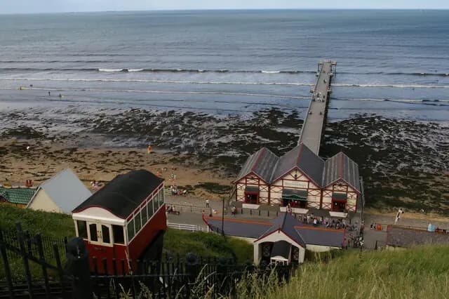
Saltburn-by-the-Sea, cliff lift and pier
Saltburn-by-the-Sea, cliff lift and pier. This photograph is used as a geographic witness to the place, not as evidence of the historical date shown in the chapter.
- Visual description
- Saltburn-by-the-Sea, cliff lift and pier
- Nature
- original
- Medium
- Open-licence photograph
- Source
- Wikimedia Commons / Geograph · CC BY-SA 2.0
- Reviewed
- Josh Wildman
LATE 20th CENTURY
Surfing gives the resort another season
Wetsuits and a growing north-east scene made Saltburn a year-round surf centre.
Shops, lessons and a strong local community developed under the surviving Victorian pier.
Sources for this chapter
THE LIVING MAP
The mapped place
Saltburn-by-the-Sea is recorded at 54.583° N, 0.974° W. A surf map fixes a name to one stretch of moving water, but the place changes with tide, swell direction, wind and the shape of the seabed.
Sources for this chapter
Open ledger · AOD.UK.SALTBURN.V00 · ORIGINALClose ledger · AOD.UK.SALTBURN.V00
Ledger AOD.UK.SALTBURN.V00
Saltburn-by-the-Sea pier and Saltburn Sands
Saltburn-by-the-Sea pier and Saltburn Sands. This photograph is used as a geographic witness to the place, not as evidence of the historical date shown in the chapter.
- Visual description
- Saltburn-by-the-Sea pier and Saltburn Sands
- Nature
- original
- Medium
- Open-licence photograph
- Source
- Wikimedia Commons / Geograph · CC BY-SA 2.0
- Reviewed
- Josh Wildman
TODAY
Victorian structure, modern line-up
Saltburn’s distinctiveness comes from the coexistence of a planned nineteenth-century resort and a living surf town.
The pier is not a nostalgic backdrop: it fixes the modern line-up to a particular history.
Sources for this chapter
THE LEDGER
Sources and credits
This exhibition is built from local, institutional and sporting records. The source ledger keeps the claims visible and leaves space for correction as further local evidence emerges.
Sources for this chapter
Artefacts in order of appearance
Saltburn-by-the-Sea pier and Saltburn Sands
AOD.UK.SALTBURN.V00 · original · Wikimedia Commons / Geograph · CC BY-SA 2.0
Saltburn-by-the-Sea, cliff lift and pier
AOD.UK.SALTBURN.V01 · original · Wikimedia Commons / Geograph · CC BY-SA 2.0
Editorial record
Full UK edition. Historical claims are linked to the local, public and sporting records used to write the exhibition. Cartography is generated from the PeakWave location catalogue.