Open ledger · AOD.UK.RUNSWICK-BAY.V00 · ORIGINALClose ledger · AOD.UK.RUNSWICK-BAY.V00
Ledger AOD.UK.RUNSWICK-BAY.V00
Runswick Bay
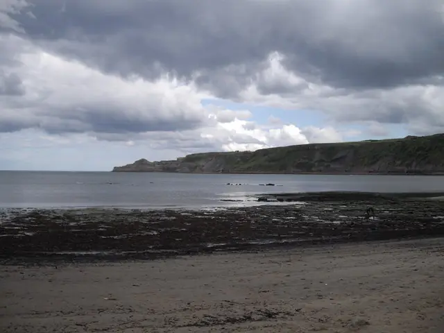
Runswick Bay. This photograph is used as a geographic witness to the place, not as evidence of the historical date shown in the chapter.
- Visual description
- Runswick Bay
- Nature
- original
- Medium
- Open-licence photograph
- Source
- Wikimedia Commons / Geograph · CC BY-SA 2.0
- Reviewed
- Josh Wildman
THE BAY
Runswick Bay
A rebuilt fishing village, alum coast and sheltered Yorkshire surf bay.
Scroll to follow the shoreline through time
Runswick Bay arcs beneath cliffs towards Kettleness.
Reef, boulders, pools and sand sit within water exposed to strong waves and currents.
Sources for this chapter
1682
The village moves after a landslip
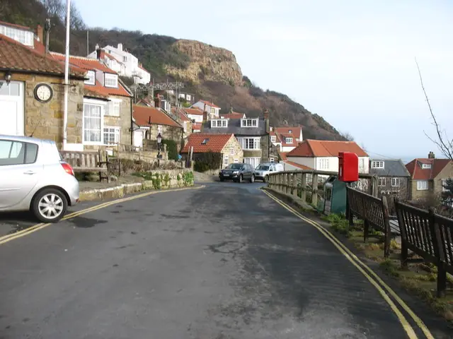
A landslip almost destroyed the original fishing village in 1682, and it was rebuilt slightly farther south.
The stacked houses record adaptation to unstable ground as well as the needs of fishing families.
Sources for this chapter
1727–1871
Alum changes the headland
Alum was quarried at Kettleness from 1727 to 1871 for the textile industry.
The workings altered the headland and connected this secluded bay to an industrial supply chain.
Open ledger · AOD.UK.RUNSWICK-BAY.V01 · ORIGINALClose ledger · AOD.UK.RUNSWICK-BAY.V01
Ledger AOD.UK.RUNSWICK-BAY.V01
In Runswick Bay village
In Runswick Bay village. This photograph is used as a geographic witness to the place, not as evidence of the historical date shown in the chapter.
- Visual description
- In Runswick Bay village
- Nature
- original
- Medium
- Open-licence photograph
- Source
- Wikimedia Commons / Geograph · CC BY-SA 2.0
- Reviewed
- Josh Wildman
THE SURF YEARS
A sheltered option on the Yorkshire coast
Modern wetsuits brought regular surfing to the North Yorkshire coast.
Runswick’s enclosed bay offered a different wind and swell response from the open beaches around Whitby and Sandsend.
Sources for this chapter
THE LIVING MAP
The mapped place
Runswick Bay is recorded at 54.536° N, 0.742° W. A surf map fixes a name to one stretch of moving water, but the place changes with tide, swell direction, wind and the shape of the seabed.
Sources for this chapter
Open ledger · AOD.UK.RUNSWICK-BAY.V00 · ORIGINALClose ledger · AOD.UK.RUNSWICK-BAY.V00
Ledger AOD.UK.RUNSWICK-BAY.V00
Runswick Bay
Runswick Bay. This photograph is used as a geographic witness to the place, not as evidence of the historical date shown in the chapter.
- Visual description
- Runswick Bay
- Nature
- original
- Medium
- Open-licence photograph
- Source
- Wikimedia Commons / Geograph · CC BY-SA 2.0
- Reviewed
- Josh Wildman
TODAY
Rescue remains local
Runswick is now a conservation area, visitor beach and occasional surf option.
A local rescue boat and daily safety notices preserve the practical coastal responsibility behind the picturesque view.
Sources for this chapter
THE LEDGER
Sources and credits
This exhibition is built from local, institutional and sporting records. The source ledger keeps the claims visible and leaves space for correction as further local evidence emerges.
Sources for this chapter
Artefacts in order of appearance
Runswick Bay
AOD.UK.RUNSWICK-BAY.V00 · original · Wikimedia Commons / Geograph · CC BY-SA 2.0
In Runswick Bay village
AOD.UK.RUNSWICK-BAY.V01 · original · Wikimedia Commons / Geograph · CC BY-SA 2.0
Editorial record
Full UK edition. Historical claims are linked to the local, public and sporting records used to write the exhibition. Cartography is generated from the PeakWave location catalogue.