Open ledger · AOD.UK.PRAA-SANDS.V00 · ORIGINALClose ledger · AOD.UK.PRAA-SANDS.V00
Ledger AOD.UK.PRAA-SANDS.V00
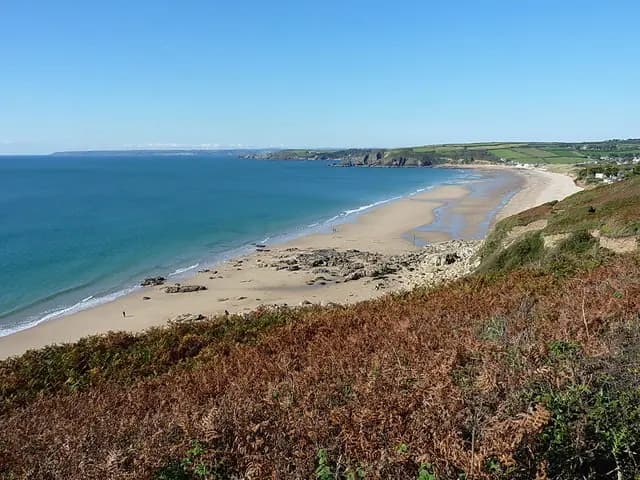
Praa Sands from Rinsey West Cliff
Praa Sands from Rinsey West Cliff. This photograph is used as a geographic witness to the place, not as evidence of the historical date shown in the chapter.
- Visual description
- Praa Sands from Rinsey West Cliff
- Nature
- original
- Medium
- Open-licence photograph
- Source
- Wikimedia Commons / Geograph · CC BY-SA 2.0
- Reviewed
- Josh Wildman
MOUNTS BAY
Praa Sands
A south-coast strand where buried peat and powerful surf reveal different past climates.
Scroll to follow the shoreline through time
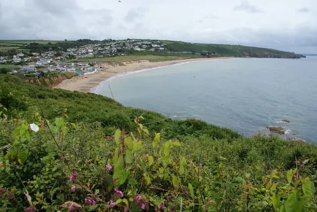
Praa Sands is a long south-west facing beach backed by dunes.
Its orientation allows Atlantic swell to reach a part of Cornwall better known for sheltered coves.
Sources for this chapter
ABOUT 2,000 YEARS AGO
Peat records an older shore
Erosion has exposed a layer of peat about two thousand years old beneath the beach and dunes.
It records land conditions unlike the present strand and makes environmental change physically visible.
Sources for this chapter
THE HOLIDAY COAST
A difficult coast became an accessible beach
Road access and beach facilities brought regular visitors to a shore once approached through farms and small settlements.
The long sand became a destination distinct from the harbours at either end of the wider bay.
Sources for this chapter
Open ledger · AOD.UK.PRAA-SANDS.V01 · ORIGINALClose ledger · AOD.UK.PRAA-SANDS.V01
Ledger AOD.UK.PRAA-SANDS.V01
Praa Sands from Hoe Point
Praa Sands from Hoe Point. This photograph is used as a geographic witness to the place, not as evidence of the historical date shown in the chapter.
- Visual description
- Praa Sands from Hoe Point
- Nature
- original
- Medium
- Open-licence photograph
- Source
- Wikimedia Commons / Geograph · CC BY-SA 2.0
- Reviewed
- Josh Wildman
THE SURF YEARS
South-coast swell found a surf community
Praa Sands became a recognised option when swell enters Mounts Bay.
Its powerful beachbreak can challenge experienced surfers, showing that Cornwall’s surf geography is not confined to the north coast.
THE LIVING MAP
The mapped place
Praa Sands is recorded at 50.095° N, 5.385° W. A surf map fixes a name to one stretch of moving water, but the place changes with tide, swell direction, wind and the shape of the seabed.
Sources for this chapter
Open ledger · AOD.UK.PRAA-SANDS.V00 · ORIGINALClose ledger · AOD.UK.PRAA-SANDS.V00
Ledger AOD.UK.PRAA-SANDS.V00
Praa Sands from Rinsey West Cliff
Praa Sands from Rinsey West Cliff. This photograph is used as a geographic witness to the place, not as evidence of the historical date shown in the chapter.
- Visual description
- Praa Sands from Rinsey West Cliff
- Nature
- original
- Medium
- Open-licence photograph
- Source
- Wikimedia Commons / Geograph · CC BY-SA 2.0
- Reviewed
- Josh Wildman
TODAY
Erosion exposes the history it threatens
Praa Sands remains a family and surf beach inside Cornwall’s protected landscape.
Continued erosion both changes access and reveals the peat record beneath, binding the beach’s future to its deepest visible past.
Sources for this chapter
THE LEDGER
Sources and credits
This exhibition is built from local, institutional and sporting records. The source ledger keeps the claims visible and leaves space for correction as further local evidence emerges.
Sources for this chapter
Artefacts in order of appearance
Praa Sands from Rinsey West Cliff
AOD.UK.PRAA-SANDS.V00 · original · Wikimedia Commons / Geograph · CC BY-SA 2.0
Praa Sands from Hoe Point
AOD.UK.PRAA-SANDS.V01 · original · Wikimedia Commons / Geograph · CC BY-SA 2.0
Editorial record
Full UK edition. Historical claims are linked to the local, public and sporting records used to write the exhibition. Cartography is generated from the PeakWave location catalogue.