Open ledger · AOD.UK.PITSFORD-WATER.V00 · ORIGINALClose ledger · AOD.UK.PITSFORD-WATER.V00
Ledger AOD.UK.PITSFORD-WATER.V00
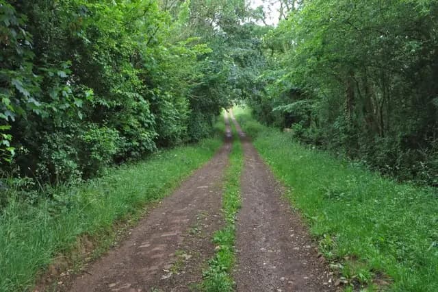
Bridleway towards the reservoir
Bridleway towards the reservoir. This photograph is used as a geographic witness to the place, not as evidence of the historical date shown in the chapter.
- Visual description
- Bridleway towards the reservoir
- Nature
- original
- Medium
- Open-licence photograph
- Source
- Wikimedia Commons / Geograph · CC BY-SA 2.0
- Reviewed
- Josh Wildman
THE WATER-SUPPLY LANDSCAPE
Pitsford Water
An inland club shaped by a working reservoir and Northamptonshire wind.
Scroll to read the water through time
Pitsford Water was created as a reservoir, replacing fields with an irregular shoreline.
Its long reaches provide open wind while wooded banks and headlands create local shifts.
Sources for this chapter
THE CLUB YEARS
A club builds the routine
Northampton Sailing Club made the reservoir usable through collective work: launching, rescue cover, race management and the maintenance of a shore base.
Sources for this chapter
THE RESERVOIR ERA
Inland access changes who can sail
A large water close to inland towns removed the need for a coastal berth.
Trailerable dinghies and club-owned systems brought regular sailing within reach of a much wider catchment.
Sources for this chapter
Open ledger · AOD.UK.PITSFORD-WATER.V01 · ORIGINALClose ledger · AOD.UK.PITSFORD-WATER.V01
Ledger AOD.UK.PITSFORD-WATER.V01
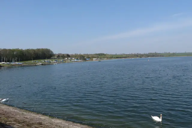
Northampton Sailing Club on Pitsford Reservoir
Northampton Sailing Club on Pitsford Reservoir. This photograph is used as a geographic witness to the place, not as evidence of the historical date shown in the chapter.
- Visual description
- Northampton Sailing Club on Pitsford Reservoir
- Nature
- original
- Medium
- Open-licence photograph
- Source
- Wikimedia Commons / Geograph · CC BY-SA 2.0
- Reviewed
- Josh Wildman
CLUB RACING
The wind draws each course
Pitsford’s courses are temporary, set for the day’s breeze and fleet.
Learning the reservoir means recognising wind shadows and gust lines that do not appear on a road map.
Sources for this chapter
THE LIVING MAP
The mapped place
Pitsford Water is recorded at 52.340° N, 0.870° W as an inland venue. A course drawn here is temporary: wind, current, shore and marks determine the water that sailors actually meet.
Sources for this chapter
Open ledger · AOD.UK.PITSFORD-WATER.V00 · ORIGINALClose ledger · AOD.UK.PITSFORD-WATER.V00
Ledger AOD.UK.PITSFORD-WATER.V00
Bridleway towards the reservoir
Bridleway towards the reservoir. This photograph is used as a geographic witness to the place, not as evidence of the historical date shown in the chapter.
- Visual description
- Bridleway towards the reservoir
- Nature
- original
- Medium
- Open-licence photograph
- Source
- Wikimedia Commons / Geograph · CC BY-SA 2.0
- Reviewed
- Josh Wildman
TODAY
A club within a managed lake
The reservoir remains a working water-supply and wildlife landscape.
Sailing continues through rules, safety systems and volunteer effort that make sport compatible with those other purposes.
Sources for this chapter
THE LEDGER
Sources and credits
This exhibition is built from local, institutional and sporting records. The source ledger keeps the claims visible and leaves space for correction as further local evidence emerges.
Sources for this chapter
Artefacts in order of appearance
Bridleway towards the reservoir
AOD.UK.PITSFORD-WATER.V00 · original · Wikimedia Commons / Geograph · CC BY-SA 2.0
Northampton Sailing Club on Pitsford Reservoir
AOD.UK.PITSFORD-WATER.V01 · original · Wikimedia Commons / Geograph · CC BY-SA 2.0
Editorial record
Full UK edition. Historical claims are linked to the local, public and sporting records used to write the exhibition. Cartography is generated from the PeakWave location catalogue.