Open ledger · AOD.UK.LLANDEGFEDD.V00 · ORIGINALClose ledger · AOD.UK.LLANDEGFEDD.V00
Ledger AOD.UK.LLANDEGFEDD.V00
Llandegfedd Reservoir
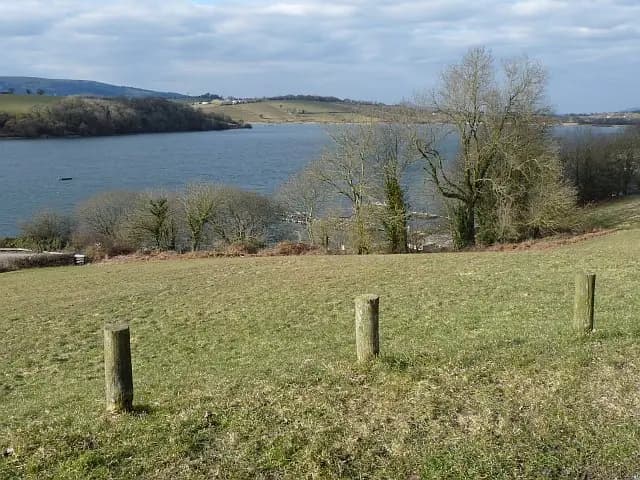
Llandegfedd Reservoir The view from the picnic site. The moorings of the Llandegfedd Sailing Club https://www.geograph.org.uk/photo/1751015 are visible through the trees. This photograph is used as a geographic witness to the place, not as evidence of the historical date shown in the chapter.
- Visual description
- Llandegfedd Reservoir The view from the picnic site. The moorings of the Llandegfedd Sailing Club https://www.geograph.org.uk/photo/1751015 are visible through the trees
- Nature
- original
- Medium
- Open-licence photograph
- Source
- Wikimedia Commons / Geograph · CC BY-SA 2.0
- Reviewed
- Josh Wildman
BEFORE SAILING
Llandegfedd Reservoir
A Welsh reservoir where a club built a sailing community from newly managed water.
Scroll to read the water through time
Llandegfedd is managed water within a rural Monmouthshire landscape.
Its shoreline and levels exist for supply first, so sporting access has always depended on agreement and stewardship.
Sources for this chapter
1968
A club begins
Llandegfedd Sailing Club was established in 1968.
Members had to create the routines, safety cover and shore facilities that turn a reservoir into a repeatable place to sail.
Sources for this chapter
FROM 1968
Launching makes the lake public
Organised launching, storage and instruction opened the reservoir to people without coastal moorings or maritime family connections.
Access became the club’s central piece of infrastructure.
Sources for this chapter
Open ledger · AOD.UK.LLANDEGFEDD.V01 · ORIGINALClose ledger · AOD.UK.LLANDEGFEDD.V01
Ledger AOD.UK.LLANDEGFEDD.V01
Llandegfedd Sailing Club
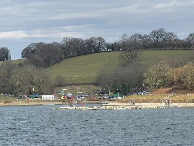
Llandegfedd Sailing Club The club website says that it offers dinghy racing in a scenic rural environment, suitable for families. This photograph is used as a geographic witness to the place, not as evidence of the historical date shown in the chapter.
- Visual description
- Llandegfedd Sailing Club The club website says that it offers dinghy racing in a scenic rural environment, suitable for families
- Nature
- original
- Medium
- Open-licence photograph
- Source
- Wikimedia Commons / Geograph · CC BY-SA 2.0
- Reviewed
- Josh Wildman
INLAND RACING
A course without a channel
Races at Llandegfedd are drawn against the wind rather than along a harbour channel.
The fleet learns shifts, gusts and shore effects particular to an inland valley.
Sources for this chapter
THE LIVING MAP
The mapped place
Llandegfedd Reservoir is recorded at 51.700° N, 3.000° W as an inland venue. A course drawn here is temporary: wind, current, shore and marks determine the water that sailors actually meet.
Sources for this chapter
Open ledger · AOD.UK.LLANDEGFEDD.V00 · ORIGINALClose ledger · AOD.UK.LLANDEGFEDD.V00
Ledger AOD.UK.LLANDEGFEDD.V00
Llandegfedd Reservoir
Llandegfedd Reservoir The view from the picnic site. The moorings of the Llandegfedd Sailing Club https://www.geograph.org.uk/photo/1751015 are visible through the trees. This photograph is used as a geographic witness to the place, not as evidence of the historical date shown in the chapter.
- Visual description
- Llandegfedd Reservoir The view from the picnic site. The moorings of the Llandegfedd Sailing Club https://www.geograph.org.uk/photo/1751015 are visible through the trees
- Nature
- original
- Medium
- Open-licence photograph
- Source
- Wikimedia Commons / Geograph · CC BY-SA 2.0
- Reviewed
- Josh Wildman
TODAY
A shared modern reservoir
Sailing now sits among several managed uses of Llandegfedd Reservoir.
The club’s continuing role is to make participation possible while respecting water operations, wildlife and other visitors.
Sources for this chapter
THE LEDGER
Sources and credits
This exhibition is built from local, institutional and sporting records. The source ledger keeps the claims visible and leaves space for correction as further local evidence emerges.
Sources for this chapter
Artefacts in order of appearance
Llandegfedd Reservoir
AOD.UK.LLANDEGFEDD.V00 · original · Wikimedia Commons / Geograph · CC BY-SA 2.0
Llandegfedd Sailing Club
AOD.UK.LLANDEGFEDD.V01 · original · Wikimedia Commons / Geograph · CC BY-SA 2.0
Editorial record
Full UK edition. Historical claims are linked to the local, public and sporting records used to write the exhibition. Cartography is generated from the PeakWave location catalogue.