Open ledger · AOD.UK.LANGLAND.V00 · ORIGINALClose ledger · AOD.UK.LANGLAND.V00
Ledger AOD.UK.LANGLAND.V00
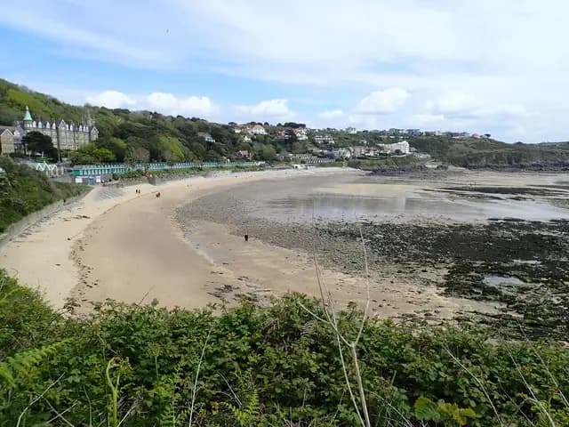
Langland Bay from the west
Langland Bay from the west. This photograph is used as a geographic witness to the place, not as evidence of the historical date shown in the chapter.
- Visual description
- Langland Bay from the west
- Nature
- original
- Medium
- Open-licence photograph
- Source
- Wikimedia Commons / Geograph · CC BY-SA 2.0
- Reviewed
- Josh Wildman
THE COVE
Langland Bay
A Victorian Gower resort cove that became a reef-and-beach centre of Swansea surfing.
Scroll to follow the shoreline through time
Langland’s sand is framed by rocky points.
The beach and surrounding reefs respond differently to swell and tide, concentrating several kinds of wave into a short section of coast.
Sources for this chapter
1894
A designed seaside landscape
The Langland Bay Hotel opened in 1894 and helped establish the cove as a Victorian resort.
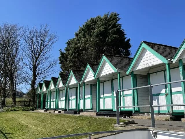
Promenades, leisure grounds and the curved line of beach huts made recreation part of the built landscape.
Sources for this chapter
20th-CENTURY SWANSEA
The cove becomes part of the city
Suburban development and roads brought Langland into Swansea’s daily orbit.
A beach once marketed as a resort became a regular local place rather than only a holiday destination.
Sources for this chapter
Open ledger · AOD.UK.LANGLAND.V01 · ORIGINALClose ledger · AOD.UK.LANGLAND.V01
Ledger AOD.UK.LANGLAND.V01
Beach huts at Langland Bay, Swansea
Beach huts at Langland Bay, Swansea. This photograph is used as a geographic witness to the place, not as evidence of the historical date shown in the chapter.
- Visual description
- Beach huts at Langland Bay, Swansea
- Nature
- original
- Medium
- Open-licence photograph
- Source
- Wikimedia Commons / Geograph · CC BY-SA 2.0
- Reviewed
- Josh Wildman
THE 1960s–1973
Welsh surfing organises
Gower’s reefs and beaches supported the community from which organised Welsh surfing grew.
The Welsh Surfing Federation was established in 1973, giving competition and representation a national structure.
Sources for this chapter
THE LIVING MAP
The mapped place
Langland Bay is recorded at 51.571° N, 3.989° W. A surf map fixes a name to one stretch of moving water, but the place changes with tide, swell direction, wind and the shape of the seabed.
Sources for this chapter
Open ledger · AOD.UK.LANGLAND.V00 · ORIGINALClose ledger · AOD.UK.LANGLAND.V00
Ledger AOD.UK.LANGLAND.V00
Langland Bay from the west
Langland Bay from the west. This photograph is used as a geographic witness to the place, not as evidence of the historical date shown in the chapter.
- Visual description
- Langland Bay from the west
- Nature
- original
- Medium
- Open-licence photograph
- Source
- Wikimedia Commons / Geograph · CC BY-SA 2.0
- Reviewed
- Josh Wildman
TODAY
A small bay with many users
Langland remains heavily used for surfing, swimming, bodyboarding and coastal walking.
Its challenge is the intensity of activity in a cove where tide can remove much of the available beach.
Sources for this chapter
THE LEDGER
Sources and credits
This exhibition is built from local, institutional and sporting records. The source ledger keeps the claims visible and leaves space for correction as further local evidence emerges.
Sources for this chapter
Artefacts in order of appearance
Langland Bay from the west
AOD.UK.LANGLAND.V00 · original · Wikimedia Commons / Geograph · CC BY-SA 2.0
Beach huts at Langland Bay, Swansea
AOD.UK.LANGLAND.V01 · original · Wikimedia Commons / Geograph · CC BY-SA 2.0
Editorial record
Full UK edition. Historical claims are linked to the local, public and sporting records used to write the exhibition. Cartography is generated from the PeakWave location catalogue.