Open ledger · AOD.UK.GLENSHEE.V00 · ORIGINALClose ledger · AOD.UK.GLENSHEE.V00
Ledger AOD.UK.GLENSHEE.V00
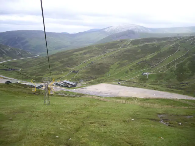
A view over the Cairnwell Pass to Carn an Tuirc
A view over the Cairnwell Pass to Carn an Tuirc. This photograph is used as a geographic witness to the place, not as evidence of the historical date shown in the chapter.
- Visual description
- A view over the Cairnwell Pass to Carn an Tuirc
- Nature
- original
- Medium
- Open-licence photograph
- Source
- Wikimedia Commons / Geograph · CC BY-SA 2.0
- Reviewed
- Josh Wildman
BEFORE THE CENTRE
Glenshee
How a high road, improvised tows and club labour built Britain’s largest ski area.
Scroll to read the contour through time
Glenshee’s ski terrain gathers around the Cairnwell Pass on the A93.
That road made high snow visible and reachable, but winter travel through the pass remained difficult enough that access itself became part of the area’s history.
Sources for this chapter
1935
First, people walked
Skiers were exploring the slopes on foot by 1935.
There was no resort to arrive at: the day consisted of the road, the climb and whatever descent the snow allowed.
Sources for this chapter
1955–1962
A tractor pulls the first tow
A tractor-powered rope tow appeared in 1955, Dundee Ski Club installed a T-bar in 1957, and the Cairnwell chair followed in 1962.
Glenshee grew by practical additions rather than a single master plan.
Sources for this chapter
Open ledger · AOD.UK.GLENSHEE.V01 · ORIGINALClose ledger · AOD.UK.GLENSHEE.V01
Ledger AOD.UK.GLENSHEE.V01
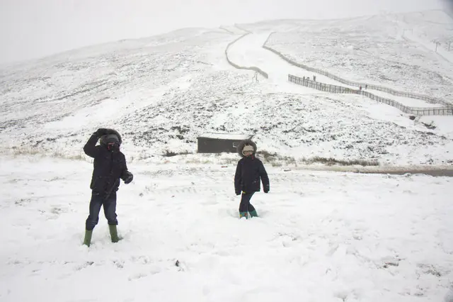
Snow at Glenshee Ski Centre
Snow at Glenshee Ski Centre. This photograph is used as a geographic witness to the place, not as evidence of the historical date shown in the chapter.
- Visual description
- Snow at Glenshee Ski Centre
- Nature
- original
- Medium
- Open-licence photograph
- Source
- Wikimedia Commons / Geograph · CC BY-SA 2.0
- Reviewed
- Josh Wildman
1969
The bypass opens the wider hill
The A93 bypass of the Devil’s Elbow improved the winter approach in 1969.
Further lifts then connected several hills and corries, producing the extensive ski area recognised today.
Sources for this chapter
THE LIVING MAP
The mapped place
Glenshee is recorded at 56.882° N, 3.420° W. Its catalogue reference reaches 1,068 metres. A modern resort map compresses terrain, exposure and access into a diagram. This exhibition keeps the underlying contour visible so the place does not become only a list of facilities.
Sources for this chapter
Open ledger · AOD.UK.GLENSHEE.V00 · ORIGINALClose ledger · AOD.UK.GLENSHEE.V00
Ledger AOD.UK.GLENSHEE.V00
A view over the Cairnwell Pass to Carn an Tuirc
A view over the Cairnwell Pass to Carn an Tuirc. This photograph is used as a geographic witness to the place, not as evidence of the historical date shown in the chapter.
- Visual description
- A view over the Cairnwell Pass to Carn an Tuirc
- Nature
- original
- Medium
- Open-licence photograph
- Source
- Wikimedia Commons / Geograph · CC BY-SA 2.0
- Reviewed
- Josh Wildman
TODAY
A large area with a short weather window
Glenshee’s linked terrain can spread skiers across a remarkable area when the snow joins up.
Snowmaking and continuing lift work support that system, but the centre still runs on the timing of Scottish winter weather.
THE LEDGER
Sources and credits
This exhibition is built from local, institutional and sporting records. The source ledger keeps the claims visible and leaves space for correction as further local evidence emerges.
Sources for this chapter
Artefacts in order of appearance
A view over the Cairnwell Pass to Carn an Tuirc
AOD.UK.GLENSHEE.V00 · original · Wikimedia Commons / Geograph · CC BY-SA 2.0
Snow at Glenshee Ski Centre
AOD.UK.GLENSHEE.V01 · original · Wikimedia Commons / Geograph · CC BY-SA 2.0
Editorial record
Full UK edition. Historical claims are linked to the local, public and sporting records used to write the exhibition. Cartography is generated from the PeakWave location catalogue.