Open ledger · AOD.UK.CAMEL-ESTUARY.V00 · ORIGINALClose ledger · AOD.UK.CAMEL-ESTUARY.V00
Ledger AOD.UK.CAMEL-ESTUARY.V00
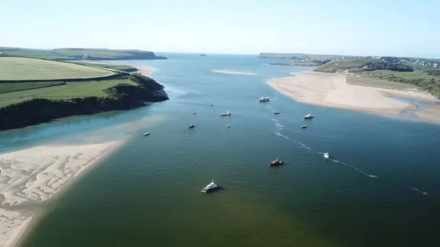
Padstow, Camel Estuary
Padstow, Camel Estuary. This photograph is used as a geographic witness to the place, not as evidence of the historical date shown in the chapter.
- Visual description
- Padstow, Camel Estuary
- Nature
- original
- Medium
- Open-licence photograph
- Source
- Wikimedia Commons / Geograph · CC BY-SA 2.0
- Reviewed
- Josh Wildman
THE ESTUARY
Camel Estuary
Fishing water, a hazardous bar and a racing class designed for one Cornish estuary.
Scroll to read the water through time
The Camel opens to the Atlantic between Padstow and Rock.
Sheltered reaches sit behind the Doom Bar, whose shifting sands made the harbour entrance a serious navigational problem for working sail.
Sources for this chapter
BEFORE CLUB RACING
Harbour, ferry and fishing water
Padstow’s harbour and the crossing to Rock made the estuary a working route long before it was a leisure course.
Boats had to suit shallow water, tide and the practical need to anchor.
Sources for this chapter
1936–1938
A boat designed for this place
Rock’s club formed in 1936 and racing began in 1938.
Its founders commissioned the Rock One Design: cheap, able to lie at anchor and low enough to sail beneath the railway bridge.
Sources for this chapter
Open ledger · AOD.UK.CAMEL-ESTUARY.V01 · ORIGINALClose ledger · AOD.UK.CAMEL-ESTUARY.V01
Ledger AOD.UK.CAMEL-ESTUARY.V01
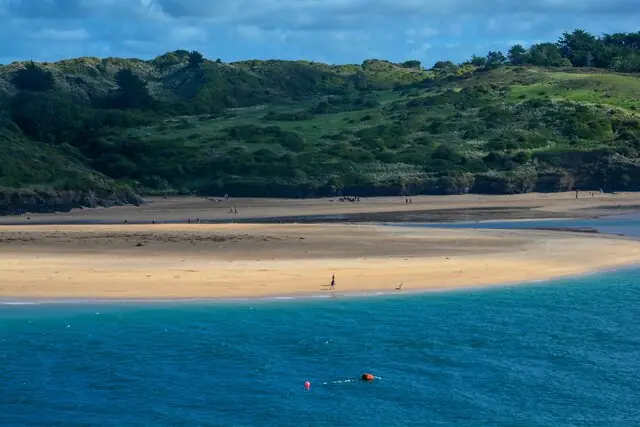
Padstow , River Camel Estuary
Padstow : River Camel Estuary. This photograph is used as a geographic witness to the place, not as evidence of the historical date shown in the chapter.
- Visual description
- Padstow : River Camel Estuary
- Nature
- original
- Medium
- Open-licence photograph
- Source
- Wikimedia Commons / Geograph · CC BY-SA 2.0
- Reviewed
- Josh Wildman
1965
Two banks build a sailing culture
Padstow Sailing Club formed in 1965, adding a second lasting centre of organised sailing.
Its later clubhouse reused a wartime blockhouse after the club had to leave the quay.
Sources for this chapter
THE LIVING MAP
The mapped place
Camel Estuary is recorded at 50.550° N, 4.930° W as an estuary venue. A course drawn here is temporary: wind, current, shore and marks determine the water that sailors actually meet.
Sources for this chapter
Open ledger · AOD.UK.CAMEL-ESTUARY.V00 · ORIGINALClose ledger · AOD.UK.CAMEL-ESTUARY.V00
Ledger AOD.UK.CAMEL-ESTUARY.V00
Padstow, Camel Estuary
Padstow, Camel Estuary. This photograph is used as a geographic witness to the place, not as evidence of the historical date shown in the chapter.
- Visual description
- Padstow, Camel Estuary
- Nature
- original
- Medium
- Open-licence photograph
- Source
- Wikimedia Commons / Geograph · CC BY-SA 2.0
- Reviewed
- Josh Wildman
TODAY
Learning the estuary
Racing, junior programmes and an RYA training centre now share the Camel with ferries, fishing craft and other water users.
The essential skill remains reading a tidal estuary rather than treating it as flat open water.
THE LEDGER
Sources and credits
This exhibition is built from local, institutional and sporting records. The source ledger keeps the claims visible and leaves space for correction as further local evidence emerges.
Sources for this chapter
Artefacts in order of appearance
Padstow, Camel Estuary
AOD.UK.CAMEL-ESTUARY.V00 · original · Wikimedia Commons / Geograph · CC BY-SA 2.0
Padstow , River Camel Estuary
AOD.UK.CAMEL-ESTUARY.V01 · original · Wikimedia Commons / Geograph · CC BY-SA 2.0
Editorial record
Full UK edition. Historical claims are linked to the local, public and sporting records used to write the exhibition. Cartography is generated from the PeakWave location catalogue.