Open ledger · AOD.UK.CAIRNGORM.V00 · ORIGINALClose ledger · AOD.UK.CAIRNGORM.V00
Ledger AOD.UK.CAIRNGORM.V00
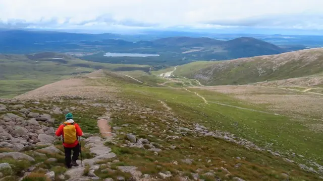
Descending north towards the Cairngorm Ski Centre
Descending north towards the Cairngorm Ski Centre. This photograph is used as a geographic witness to the place, not as evidence of the historical date shown in the chapter.
- Visual description
- Descending north towards the Cairngorm Ski Centre
- Nature
- original
- Medium
- Open-licence photograph
- Source
- Wikimedia Commons / Geograph · CC BY-SA 2.0
- Reviewed
- Josh Wildman
BEFORE THE SKI ROAD
Cairngorm
From a high plateau and working glen to Scotland’s best-known ski mountain.
Scroll to read the contour through time
Cairn Gorm rises from a broad granite plateau rather than a single Alpine-shaped summit.
Wind, snow and exposed ground connect the mountain to a much larger upland system whose scale determined every later attempt to travel and ski here.
Sources for this chapter
1890s–1940s
Skiers came before the centre
People were skiing on Cairn Gorm by the 1890s.
Those early journeys were made without a commercial lift network, when reaching snow and moving across it were still part of the same expedition.
Sources for this chapter
THE 1950s
Coire Cas becomes reachable
The Cairngorm Sports Development Fund formed in the 1950s to establish commercial skiing in Coire Cas.
A road and mechanical uplift changed a mountain outing into a repeatable day of lift-served skiing.
Open ledger · AOD.UK.CAIRNGORM.V01 · ORIGINALClose ledger · AOD.UK.CAIRNGORM.V01
Ledger AOD.UK.CAIRNGORM.V01
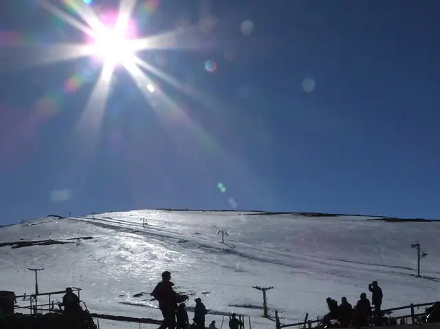
Noon sunshine at Cairngorm Ski Centre
Noon sunshine at Cairngorm Ski Centre. This photograph is used as a geographic witness to the place, not as evidence of the historical date shown in the chapter.
- Visual description
- Noon sunshine at Cairngorm Ski Centre
- Nature
- original
- Medium
- Open-licence photograph
- Source
- Wikimedia Commons / Geograph · CC BY-SA 2.0
- Reviewed
- Josh Wildman
2001
A mountain railway changes the system
The funicular opened in 2001.
It concentrated access on a single piece of infrastructure, linking the base and upper mountain while also making the operation’s dependence on weather, engineering and public investment unusually visible.
Sources for this chapter
THE LIVING MAP
The mapped place
Cairngorm is recorded at 57.120° N, 3.670° W. Its catalogue reference reaches 1,245 metres. A modern resort map compresses terrain, exposure and access into a diagram. This exhibition keeps the underlying contour visible so the place does not become only a list of facilities.
Sources for this chapter
Open ledger · AOD.UK.CAIRNGORM.V00 · ORIGINALClose ledger · AOD.UK.CAIRNGORM.V00
Ledger AOD.UK.CAIRNGORM.V00
Descending north towards the Cairngorm Ski Centre
Descending north towards the Cairngorm Ski Centre. This photograph is used as a geographic witness to the place, not as evidence of the historical date shown in the chapter.
- Visual description
- Descending north towards the Cairngorm Ski Centre
- Nature
- original
- Medium
- Open-licence photograph
- Source
- Wikimedia Commons / Geograph · CC BY-SA 2.0
- Reviewed
- Josh Wildman
TODAY
Snow remains the deciding factor
Cairngorm still supports skiing and snowboarding when conditions allow, but the mountain is not a fixed product.
Operations are shaped by wind, snow cover, conservation and the practical limits of maintaining uplift on an exposed plateau.
Sources for this chapter
THE LEDGER
Sources and credits
This exhibition is built from local, institutional and sporting records. The source ledger keeps the claims visible and leaves space for correction as further local evidence emerges.
Sources for this chapter
Artefacts in order of appearance
Descending north towards the Cairngorm Ski Centre
AOD.UK.CAIRNGORM.V00 · original · Wikimedia Commons / Geograph · CC BY-SA 2.0
Noon sunshine at Cairngorm Ski Centre
AOD.UK.CAIRNGORM.V01 · original · Wikimedia Commons / Geograph · CC BY-SA 2.0
Editorial record
Full UK edition. Historical claims are linked to the local, public and sporting records used to write the exhibition. Cartography is generated from the PeakWave location catalogue.